
The Road to IRONBEARD: Part 2
Last week was the beginning. Now we’re getting into the thick of it. This week was supposed to cover both bike accessories and the planned route. However, that became too long and preparation continues to evolve. We’ll discuss the route this week and bike prep next week.
Note: All map and elevation illustrations are screenshots from Rever.
If I have any chance of making this trip successful, as much traffic control (stop signs, traffic lights, etc) must be avoided as possible. Also, you know, traffic. That means that, before I can ride 1000 miles, I have to ride an hour (and over 40 miles) to the starting point. I could get a hotel closer to the starting point but I know I wouldn’t get any sleep. Best to just start riding from my house.
Leg 1 – 293 miles

Adelanto to Tonopah via Death Valley
The highest number of roads ridden on will be in the first leg. It will also be the longest. Riding begins at a gas station in Adelanto on US-395. Highway speeds mean I will be the slowest thing on the road by a large margin. It isn’t illegal, just annoying. My rolling roadblock heads north on 395 for 55 miles until a little town called Red Mountain (pop. 131). From there, Trona Rd is followed to Panamint Valley Rd and then CA-190 into Death Valley. The fuel tank will run dry somewhere before crossing the National Park boundary. That is probably for the best as I want to film the first refuel and I have not secured a permit to film in the park.
Daylight Pass Rd is how I will find my way out of Death Valley and to the last road on leg one, US-95. My first planned gas station stop is in Tonopah, NV. I believe there are less than 5 total stop signs in the first leg.
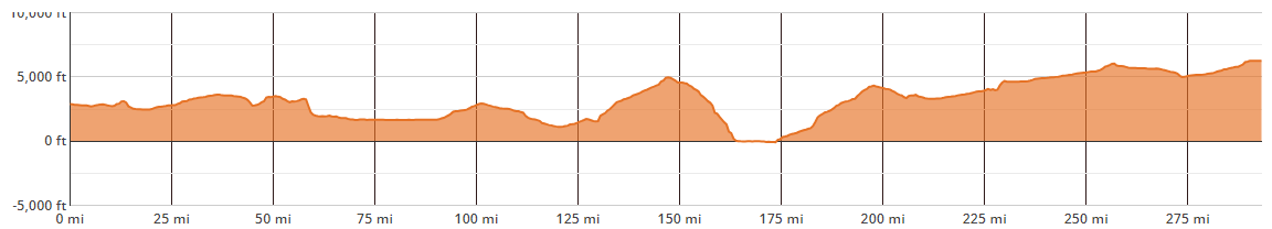
Leg 1 elevation profile. Can you see where Death Valley is located in this picture?
Leg 2 – 243 miles

Tonopah to Ely…the long way
Leaving Tonopah, I head north on NV-376 and turn right in Austin onto US-50.
The highest elevation of the trip will be reached at just over 7600ft just before arriving in Ely, NV. The gas station stop is at a Love’s Travel Center on the other side of town.
The route from Tonopah to Ely is shorter via US-6 but we aren’t looking for efficiency here. I’m riding in a 1000-mile figure 8.
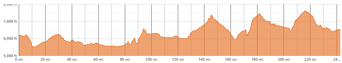
Leg 2 elevation profile. The road into Ely resembles my yoyo dieting.
Leg 3 – 284 miles

US-6 all the way
Legs 3 and 4 are the least difficult to navigate. Leg 3 is US from Ely, NV to Bishop, CA via US-6. This is also why I am not riding US-6 in leg 2. I want to at least inject some variety into the scenery.
This leg will bring me through Tonopah a second time but there should be no reason to stop for gas on my way back to California.

Leg 3 elevation profile. Finally (mostly) heading downhill. Hoping I can make up some losses.
Leg 4 – 209 miles

The most dangerous part of the final leg is not being up for 24 hours. It is the speed of traffic.
The home stretch returns the trip back to US-395. Unlike the first leg, all 209 miles are on a very fast highway with vehicles known to travel over 90mph.
1000 miles will be reached before arrival at the start/finish destination. I may or may not find a place to stop once I hit 1k. It will depend entirely upon my mood and condition whether I stop short for a break before reaching the ‘finish.’

Leg 4 elevation profile. The entire endeavor may come down to this stretch of road.
Total mileage for the trip from my driveway and back is nearly 1150.

Just a big 8 drawn between California and Nevada
Shakedown
There are many unknowns. A few will be worked out in a couple weeks. I will travel the first part of the trip (ending in Beatty, NV) where I expect the worst gas mileage and average speed to be. Hills will play a major role in my success or failure.
My average speed up a nearly 6% grade is 39.4mph (indicated by GPS). However, that is without carrying the fuel and supplies I will require for the journey through the desert. None of the grades I will experience will be over 6% but I will be 20-30lbs heavier. I have to hope whatever level ground and downhill sections of the route will make up for fighting gravity on the climbs.
Fuel range may be true limiting factor. I achieve 120mpg around town. My last fill-up was 98. I have reports that I may see 77mpg or less during long stretches at WFO. If that degradation of fuel range is realized, I won’t have enough supplemental gas onboard to travel two of the four planned legs between gas stations. More fuel equals more weight equals slower progress. The route may require revision, as well.
Equipment, supplies and accessories will be discussed next week.